




Environment Canada issued a severe thunderstorm watch for the Lloydminster area Wednesday morning, warning of strong wind gusts, large hail and heavy rain.
The watch was issued at 10:32 a.m. Some storms in the area may produce tornadoes.
Severe thunderstorms are expected to develop over the region Wednesday afternoon and evening. Environment Canada says the threat will continue into the overnight hours across central and eastern Alberta.







Local utility outages are possible, along with damage to roofs, fences and tree branches. Heavy rain could cause flash flooding and sharply reduce visibility on area roads.
The watch is part of a broader severe weather system moving across Alberta and Saskatchewan through Thursday. The Weather Network reports a slow-moving low pressure system north of Edmonton, combined with a surface trough along the Alberta-Saskatchewan border, is driving the risk.
Conditions are favourable for supercells capable of producing hail up to golf ball size and damaging winds, according to The Weather Network. Southern Alberta faces the widest severe storm risk Wednesday, with activity expected to push east into Saskatchewan through the evening.
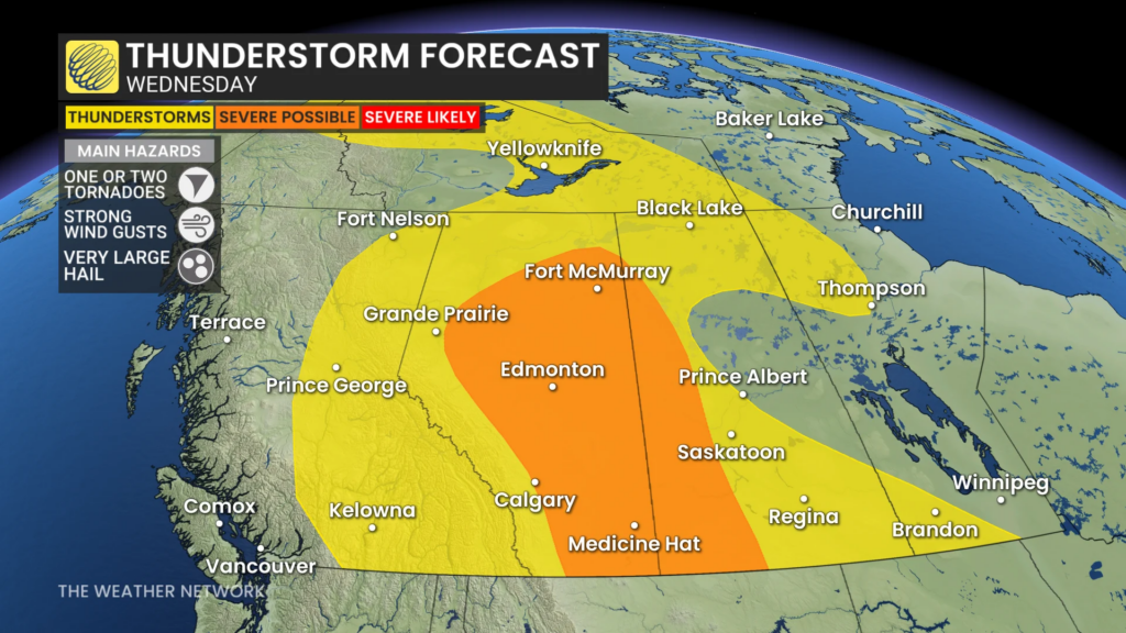
Thursday’s threat is expected to grow further. A low pressure system over northern Alberta and Saskatchewan, paired with a lingering trough along the Rockies, is forecast to fuel widespread storms stretching from the foothills into northern Saskatchewan.
The region has already seen severe weather this season. <cite index=”3-1″>A tornado warning was issued for the area near Paradise Valley on July 8, with a storm line tracking directly toward Lloydminster.</cite> That warning came during a season Alberta has already logged a sharp rise in confirmed tornadoes compared to last year.
Environment Canada is asking anyone who spots severe weather to email ABstorm@ec.gc.ca, call 1-800-239-0484, or post reports on X using #ABStorm.
Residents are urged to take cover immediately in a basement or interior room if threatening weather approaches, and to stay away from windows. Those caught outdoors should seek hard shelter and protect themselves from flying debris and hail.
Loose outdoor items should be secured before storms arrive, and drivers should avoid flooded roadways.
BorderPulse will update or socials as the day goes along.
Read more: photos – Tornado damages buildings in County of Vermilion River